

 (843) 343-4542
 gerry@mda-recon.com
 Gerald C. McDevitt
Low Delta-V Collisions and Disputed Injury Claims: What the Physics Actually Show
Low-speed impacts produce less vehicle damage but can still generate significant occupant forces — forensic reconstruction can distinguish…
High-resolution drone imagery, centimeter-accurate GNSS positioning, and 3D point cloud scanning have fundamentally changed what a reconstructionist can document and prove at trial.
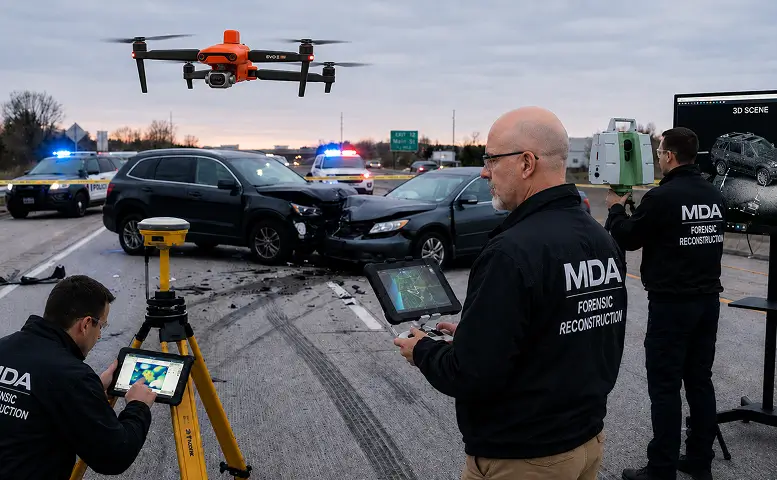
For decades, forensic scene documentation meant a team of investigators with tape measures and rolling wheels carefully plotting individual measurements at a collision scene. The results depended heavily on what the investigator decided to measure, and once the scene was cleared and the road reopened, any measurement not taken became difficult to recover — often possible only by working from scene photographs, and only if suitable photographs existed.
Modern forensic technology has fundamentally changed that equation. The combination of GNSS satellite positioning with RTK correction, RTK-equipped drones for aerial mapping, total station measurement, and photogrammetry processing now allows a single reconstructionist to document a collision scene as one measured dataset, with each measurement documented to the accuracy of the instrument and method that captured it — producing comprehensive, measurable, and verifiable data that can be revisited and analyzed long after the physical scene has been cleared.
GNSS (Global Navigation Satellite System) positioning provides the framework for modern forensic scene documentation. Using a base station and rover with real-time kinematic (RTK) correction — or the same correction applied afterward in post-processing — a GNSS receiver can achieve centimeter-level positional accuracy in the field. That level of accuracy depends on the receiver holding a fixed correction solution with a clear view of the sky; heavy tree cover and tall structures can prevent it, and vertical accuracy is always somewhat lower than horizontal. GNSS is used to map roadway geometry, grade, sight distance, and the extent of the scene, and to set the control points that tie everything else to real-world coordinates.
This matters for several reasons. First, centimeter-level accuracy substantially reduces measurement uncertainty and — more importantly — allows the remaining uncertainty to be quantified and reported rather than guessed at when scene documentation is challenged. Second, geographic coordinates allow the scene data to be integrated directly with aerial imagery, mapping databases, and satellite photos for context and courtroom presentation. Third, the recorded data is archived and can be re-examined, and fixed roadway features such as curbs, signs, and pavement edges can be independently re-measured at the same coordinates by another qualified expert.
Perhaps the most significant advancement in forensic scene documentation is the use of RTK-equipped drones for aerial mapping. A drone flown over a collision scene captures hundreds of high-resolution overlapping photographs from above the site. These images are then processed through photogrammetry software to produce orthomosaic maps — geometrically corrected aerial images scaled to real-world coordinates — and 3D surface models of the area flown.
The result is a measurable aerial view of the collision scene at a level of detail that ground-level photographs rarely achieve. Tire marks, gouge marks, debris, marked evidence locations, lane markings, intersection geometry, and roadway conditions present and visible when the flight is made are recorded in a single dataset, and the 3D surface model supports later sight-line analysis. Measurements can be taken from the orthomosaic later, between any two visible points, without returning to the scene. Because an orthomosaic is corrected to the modeled ground surface, objects that stand above it — vehicles, poles, guardrail — can appear shifted from their true position, so measurements are taken at ground level, such as tire contact points, rather than across the top of a vehicle.
The aerial dataset is tied to ground control points established with RTK-corrected GNSS, placing it in the same coordinate framework as the total station and GNSS measurements taken on the ground. Photogrammetric accuracy is not a fixed manufacturer specification — it is a function of flight altitude, image overlap, and the quality of the ground control established at that particular scene, and the control residuals — together with independent check-point results where check points are set — are reported with the work product. What the aerial dataset adds is coverage: the full area flown is recorded, not only the specific points the investigator chose to measure. Areas hidden from above, such as under tree canopy or inside structures, are documented on the ground instead.
The total station remains an essential component of forensic scene documentation, particularly for evidence-grade points — gouges, scrapes, tire mark endpoints, and marked or documented rest positions — as well as roadway cross-sections, grade measurements, and areas where the view from the air is obstructed by tree canopy or structures. A reflectorless total station measures distances within a published tolerance of a few millimeters at typical scene distances, so points are located relative to one another with millimeter-level precision; once tied to GNSS control, their real-world position carries the GNSS tolerance. How well a measured point represents a piece of evidence also depends on how clearly that evidence is defined on the ground.
In modern forensic practice, the total station works in combination with GNSS and drone data rather than as a standalone tool. Data from all three methods is combined into a single coordinate framework, with each measurement documented to the accuracy of the instrument that captured it. Ground-level points supplement the aerial data and can serve as independent check points on it, creating a multi-source dataset in which each technology’s strengths complement the others.
Scene documentation is only part of the forensic picture. How vehicles behave on a specific roadway — braking distances, friction characteristics, vehicle response in curves and lane changes — is best measured through field testing with validated instrumentation, ideally on the roadway where the collision occurred. GNSS-based vehicle data loggers, such as the Racelogic VBOX, record position and speed many times per second during controlled test runs with a test vehicle; acceleration, deceleration, and lateral forces are then derived from that recorded data.
This data can be overlaid onto synchronized video footage — both ground-level and aerial drone video — producing courtroom demonstratives that show the data in motion. A judge or jury watching an aerial view of the roadway with speed, position, and braking data displayed on screen can often grasp the physics involved more readily than from a static diagram or a verbal explanation alone. Each overlay should be clearly labeled as a test run, not a recreation of the collision. Telemetry overlay turns raw test data into visual presentations that make complex technical findings accessible to non-technical audiences.
Collision reconstruction sometimes requires detailed documentation of vehicle interiors, building interiors, or confined spaces where traditional measurement methods are impractical. Handheld LiDAR scanning with a mobile device records close-range spatial relationships in a measurable 3D model. The known distance between AprilTag targets placed at the scene is entered in the Recon3D software before the scan, and the scan is scaled to that distance.
This capability is also valuable for documenting vehicle damage from the interior perspective — intrusion measurements, occupant compartment dimensions, and the spatial relationship between vehicle components and the occupant’s seating position. Combined with exterior scene data, interior scans add the vehicle’s perspective to the documentation of the scene.
Many law enforcement agencies, government investigators, and other forensic experts document collision and crime scenes using terrestrial laser scanners that produce dense 3D point clouds containing millions of located data points. When this scanner data is part of the discovery materials in a case, a qualified reconstructionist can import, process, and analyze the point cloud data using specialized software — extracting measurements, generating cross-sections, and integrating the data with other evidence sources. Working with laser scanner data received through discovery means that evidence captured by another party’s equipment can be examined independently, provided the native scan files and registration data are produced.
For the attorney evaluating a reconstruction expert, the technology used for scene documentation matters because it directly affects the quality, completeness, and verifiability of the forensic work product.
Completeness. Drone-based aerial mapping records the full area flown, not just the points the investigator decided to measure. If a question arises six months into litigation about a grade, a lane width, or the position of a roadway feature, the answer is often already in the data.
Accuracy. GNSS with RTK correction delivers centimeter-level positional accuracy across the scene when a fixed solution is held, and the total station locates individual evidence points relative to one another with millimeter-level precision. Aerial photogrammetry is tied to the same ground control, with its residuals reported with the work product. Documenting accuracy per instrument and per method, rather than as a single blended figure, allows the uncertainty in each measurement to be stated and tested — which bears directly on reliability, a central question when a court decides whether expert testimony is admissible.
Preservation. A collision scene is temporary. The road reopens, vehicles are towed, weather degrades evidence. Drone orthomosaics, GNSS data, and total station measurements preserve a measurable digital record of the scene as it existed when documented, which can be revisited as many times as the case requires.
Courtroom presentation. Aerial scene maps, telemetry-overlaid video, and 3D models turn complex spatial relationships into visual presentations that help judges and juries follow the evidence. Their purpose is to make the technical findings understandable to non-technical audiences.
When evaluating a reconstruction expert for a serious collision case, ask what technology they use to document the scene, and how they report the accuracy of each measurement method. Scene documentation that combines GNSS positioning, aerial mapping, total station measurement, vehicle dynamics testing, and handheld LiDAR scanning — each with its accuracy stated — gives the attorney, the court, and any opposing expert a more complete record to examine. In litigation where significant damages or a defendant’s liberty is at stake, the quality of the scene documentation is a foundation on which much of the analysis rests.
32+ years of experience. Hundreds of fatal and serious injury collisions reconstructed or investigated. Qualified and accepted as an expert in state, federal, and military courts.
Gerald C. McDevitt
Low-speed impacts produce less vehicle damage but can still generate significant occupant forces — forensic reconstruction can distinguish…
 Gerald C. McDevitt
Proving that impairment caused a fatal collision — not just that the driver was impaired — requires a…
 Gerald C. McDevitt
A vehicle cannot leave a scene without leaving evidence — paint transfer, glass, tire impressions, and debris patterns…
 Gerald C. McDevitt
Tractor-trailer and fleet vehicle collisions involve federal regulatory requirements, electronic logging devices, and complex vehicle dynamics that demand…